Ecoregions of Saskatchewan
An ecoregion is a relatively large area of land that contains a geographically
distinct pattern of recurring ecosystems. Each ecoregion is associated
with characteristic combinations of soil, landforms, and the associated
plant and animal communities. There are 11 ecoregions in Saskatchewan.
Ecoregion descriptions and maps based on material developed by Environment Canada. © Her Majesty The Queen in Right of Canada, as represented by Environment Canada, 2008. reproduced with the permission of the minister of public works and government services canada.
Note: The maps below open in a new window.
|
|
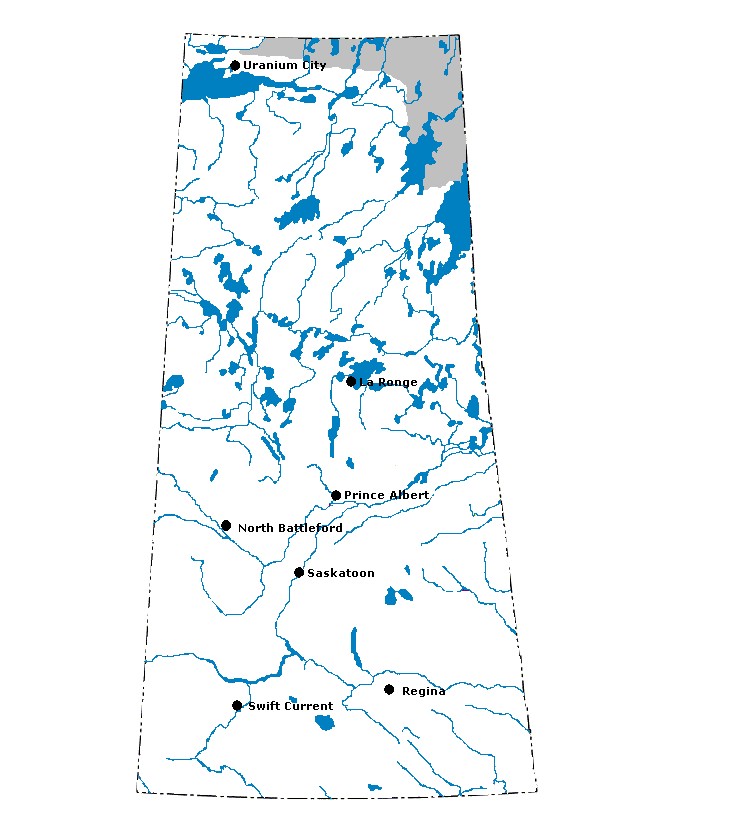
Selwyn Lake Upland: This ecoregion extends northwest from Churchill River in Manitoba to the East Arm Hills at the eastern end of Great Slave Lake. Most of the ecoregion is above 500 m above sea level (asl). At the Saskatchewan/Manitoba border the surface gently slopes towards the Hudson Plains ecozone at 150 m asl. This ecoregion is marked by cool summers and very cold winters. The mean annual temperature is approximately -5°C. The mean summer temperature is 11°C and the mean winter temperature is -21.5°C. The mean annual precipitation ranges from 250-400 mm. The ecoregion is classified as having a low subarctic ecoclimate. It is part of the tundra and boreal forest transition extending from Labrador to Alaska. Black spruce (Picea mariana) is the climatic species, and open stands of low, stunted black spruce with dwarf birch and Labrador tea, and a ground cover of lichen, and moss, are characteristic. Bog-fen sequences composed of stunted black spruce, ericaceous shrubs, and mosses dominate poorly drained wetlands. Wetlands cover 25-50% of the southeastern part of the ecoregion in Manitoba. Ridged to hummocky crystalline, massive rocks that form broad, sloping uplands and lowlands are covered with discontinuous acidic, sandy tills. Significant shallow, clayey lacustrine deposits occur at lower elevations. Prominent sinuous esker ridges and lakes are common throughout the region. Permafrost is extensive and discontinuous with low to medium ice content and sporadic ice wedges throughout most of the ecoregion, but grades to sporadic discontinuous with low ice content along the southern edges. Dystric Brunisols and Organic Cryosols are the most widely distributed soil types. Gray Luvisols occur as inclusions on exposed clayey sediments. Characteristic wildlife includes barren-ground caribou, black bear, wolverine, marten, timber wolf, arctic fox, mink, snowshoe hare, and red-backed vole. Upland game birds are spruce grouse and willow ptarmigan, and other bird species include sandhill crane, waterfowl and shorebirds. Land use activities are limited to trapping and hunting, and recreation. The major communities include Wollaston Lake, Lac Brochet, and Brochet. The population of the ecoregion is approximately 1,600.
|
|
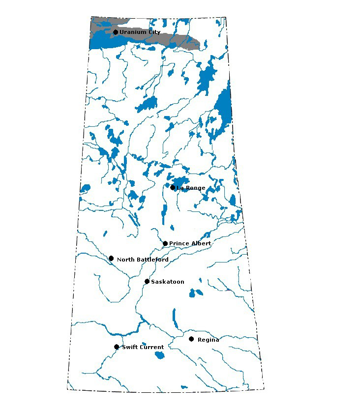
Tazin Lake Upland: This ecoregion stretches north from Lake Athabasca to beyond the east arm of Great Slave Lake. It is marked by cool summers and very cold winters, and has a subhumid, high boreal ecoclimate. The mean annual temperature is approximately -5°C. The mean summer temperature is 11°C and the mean winter temperature is -21.5°C. The mean annual precipitation ranges from 200–375 mm. Yellowknife, on the north shore of Great Slave Lake, has the lowest mean annual temperature of all Canadian cities (-5°C) and the lowest average nighttime winter temperature (-30°C). Vegetation in the ecoregion is characterized by medium to tall, closed stands of trembling aspen and balsam poplar with white spruce (Picea glauca), balsam fir (Abies balsamea), and black spruce (Picea mariana) occurring in late successional stages. Poorly drained fens and bogs are covered with low, open stands of tamarack and black spruce and have localized permafrost. North of the East Arm Hills and in the southern one-third of the ecoregion, ridged to hummocky crystalline bedrock forms broad, steeply sloping terrain. The East Arm Hills, formed of down-faulted and folded, differentially eroded sediments and gabbro sills, dip southerly, forming broad cuestas as much as 275 m above Great Slave Lake, the surface of which is about 150 m asl. The intervening valleys are flooded by arms of Great Slave and other lakes. Upland elevations are dominated by bedrock exposures with discontinuous veneers of sandy till, whereas the lowlands are covered by level to gently undulating organic deposits. The ecoregion contains numerous small lakes, often linked by fast-flowing streams that eventually drain into Great Slave Lake. Strongly glaciated rock outcrops are common, and Dystric Brunisols are the dominant soils. Significant inclusions are Turbic Cryosols on permanently frozen sites and Organic Cryosols in poorly drained, peat-filled depressions. Permafrost is extensive and discontinuous with low ice content and sparse ice wedges throughout most of the ecoregion, with the exception of the west side between Lake Athabasca and Great Slave Lake towards the Slave River. Wildlife includes moose, black bear, woodland caribou, wolf, beaver, muskrat, snowshoe hare, and spruce grouse. Land uses include limited local sawlog forestry, outdoor recreation, wildlife trapping and hunting, and fishing. Major communities include Yellowknife, Uranium City, Reliance, Rae, Edzo, and Fort Chipewyan. The population of the ecoregion is approximately 18,100.
|
|
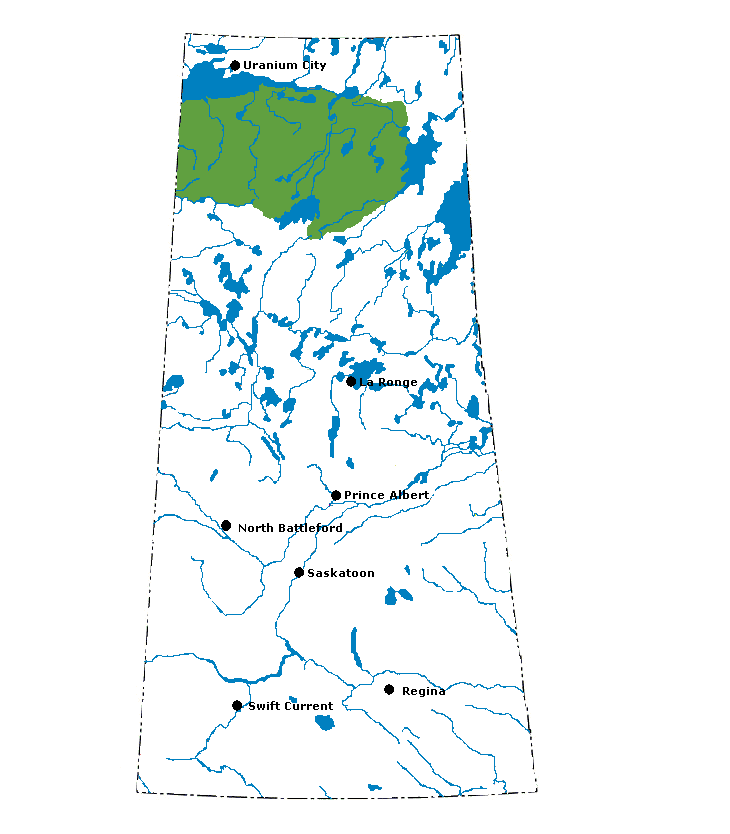
Athabasca Plain: This ecoregion extends south from Lake Athabasca to Cree Lake in northwestern Saskatchewan, and is roughly coincident with the flat-lying Proterozoic sandstones. It is marked by short cool summers and very cold winters. The mean annual temperature is approximately -3.5°C. The mean summer temperature is 12°C and the mean winter temperature is -20.5°C. The mean annual precipitation ranges from 350–450 mm. This ecoregion is classified as having a subhumid high boreal ecoclimate. It forms part of the continuous coniferous boreal forest that extends from northwestern Ontario to Great Slave Lake in the Northwest Territories. Stands of jack pine with an understory of ericaceous shrubs and lichen are dominant. Some paper birch, white spruce, black spruce, balsam fir, and trembling aspen occur on warmer, south-facing sites. Forest fires are common in this ecoregion, and most coniferous stands tend to be young and stunted. Bedrock exposures have few trees and are covered with lichens. Permafrost occurs sporadically throughout the ecoregion. The plain is covered with undulating to ridged fluvioglacial deposits and sandy, acidic till. Sandy Dystric Brunisols are dominant, whereas Organic Fibrisols and Organic Cryosols are associated with peat plateaus, palsas and organic veneers. Wetlands are extensive in the western third of the ecoregion. Local areas of eolian sandy Regosols occur along the southern shore of Lake Athabasca. The plain slopes gently and drains northwestward via Lake Athabasca, Slave River, and a network of tributary secondary streams and drainageways. Small to medium-sized lakes are more numerous to the northeast. Wildlife includes moose, black bear, woodland caribou (important winter range), lynx, wolf, beaver, muskrat, snowshoe hare, waterfowl (including ducks, geese, pelicans, and sandhill cranes), grouse, and other birds. Resources in the southern section of the ecoregion are used for local sawlog forestry. Trapping, hunting, fishing, and industrial activities associated with uranium mining are the dominant uses of land in this ecoregion. Stony Rapids and Cree Lake are the main communities. The population of the ecoregion is approximately 1,100.
|
|
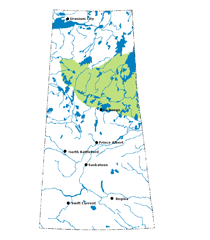
Churchill River Upland: This ecoregion is located along the southern edge of the Precambrian Shield in north-central Saskatchewan and Manitoba. It is marked by cool summers and very cold winters. The mean annual temperature is approximately -2.5°C. The mean summer temperature is 12.5°C and the mean winter temperature is -18.5°C. The mean annual precipitation ranges from 400–500 mm. This ecoregion is classified as having a subhumid high boreal ecoclimate. It forms part of the continuous coniferous boreal forest that extends from northwestern Ontario to Great Slave Lake in the southern Northwest Territories. The predominant vegetation consists of closed stands of black spruce and jack pine with a shrub layer of ericaceous shrubs and a ground cover of mosses and lichens. Black spruce is the climatic climax species. Depending on drainage, surficial material and local climate, trembling aspen, white birch, white spruce, and to a lesser extent balsam fir, occupy significant areas, especially in the eastern section. Bedrock exposures have fewer trees and are covered with lichens. Closed to open stands of stunted black spruce with ericaceous shrubs and a ground cover of sphagnum moss dominate poorly drained peat-filled depressions. Permafrost is distributed throughout the ecoregion, but is only widespread in organic deposits. Although local relief rarely exceeds 25 m, ridged to hummocky, massive Archean rocks form steeply sloping uplands and lowlands. Small to large lakes compose 30–40% of the ecoregion and drain northeastward via the Churchill, Nelson and Seal river systems. In the western part of the ecoregion, uplands are covered with discontinuous sandy acidic tills, whereas extensive thin clayey lacustrine deposits and locally prominent, sandy fluvioglacial uplands are common in the eastern section. Exposed bedrock occurs throughout the ecoregion and is locally prominent. Dystric and Eutric Brunisols are associated with sandy uplands, whereas Gray Luvisols occur on clayey lacustrine uplands and loamy to silty fluvioglacial deposits. On level and in depressional areas, Gleysolic soils are associated with clayey sediments, whereas Mesisols and Organic Cryosols are associated with shallow to deep peatlands. A pulpwood and dimension lumber industry operates to a limited extent in the southern part of the ecoregion. Wildlife includes barren-ground caribou, moose, black bear, lynx, wolf, beaver, muskrat, snowshoe hare and red-backed vole. Bird species include raven, common loon, spruce grouse, bald eagle, gray jay, hawk owl, and waterfowl, including ducks and geese. Trapping, hunting, fishing, and tourism are the dominant uses of land in this region. The major communities include Flin Flon and La Ronge. The population of the ecoregion is approximately 28,000.
|
|
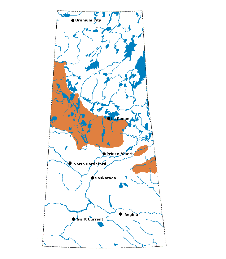
Mid-Boreal Upland: This mid-boreal ecoregion occurs as 10 separate, mostly upland areas, south of the Canadian Shield, stretching from north-central Alberta to southwestern Manitoba. It includes remnants of the Alberta Plateau in Alberta, several prominent uplands known locally as the Thickwood, Pasquia, and Porcupine hills in Saskatchewan, and the Duck and Riding mountains in Manitoba. The climate has predominantly short, cool summers and cold winters. The mean annual temperature ranges from -1°C to 1°C. The mean summer temperature ranges from 13°C to 15.5°C and the mean winter temperature ranges from -13.5°C to -16°C. Some areas of the ecoregion can be very cold with winter mean temperatures exceeding -17°C in northern Alberta. The mean annual precipitation ranges from 400–550 mm. The ecoregion is classified as having a predominantly subhumid mid-boreal ecoclimate. These uplands form part of the continuous mid-boreal mixed coniferous and deciduous forest extending from northwestern Ontario to the foothills of the Rocky Mountains. Medium to tall, closed stands of trembling aspen and balsam poplar with white and black spruce, and balsam fir occurring in late successional stages, are most abundant. Deciduous stands have a diverse understory of shrubs and herbs; coniferous stands tend to promote feathermoss. Cold and poorly drained fens and bogs are covered with tamarack and black spruce. Consisting for the most part of Cretaceous shales, these uplands are covered entirely by kettled to dissected, deep, loamy to clayey-textured glacial till, lacustrine deposits, and inclusions of coarse, fluvioglacial deposits. Elevations range from about 400 to over 800 m asl. Associated with rougher morainal deposits are a large number of small lakes, ponds, and sloughs occupying shallow depressions. Permafrost is very rare and found only in peatlands. Well-drained Gray Luvisolic soils are dominant in the region. Significant inclusions are peaty-phase Gleysols and Mesisols that occupy poorly drained depressions. Dystric Brunisols occur on droughty, sandy sites. In Alberta, the ecoregion slopes gently and drains northward via the Athabasca and Clearwater rivers and their tributaries, whereas in most of Saskatchewan and Manitoba the uplands slope gently and drain northeastward via the Churchill and North Saskatchewan river systems. Characteristic wildlife includes moose, white-tailed deer, elk, black bear, timber wolf, lynx, snowshoe hare, beaver, and muskrat. Bird species include common loon, red-tailed hawk and neotropical migrants. Pulpwood and local sawlog forestry, water-oriented recreation, hunting, and trapping are the main land use activities. Agricultural activities are significant in southern parts of the ecoregion, particularly in Saskatchewan and Manitoba. Major communities include Fort Assiniboine, Trout Lake, Peerless Lake, La Loche, Buffalo Narrows, and Île-à-la Crosse. The population of the ecoregion is approximately 45,200.
|
|
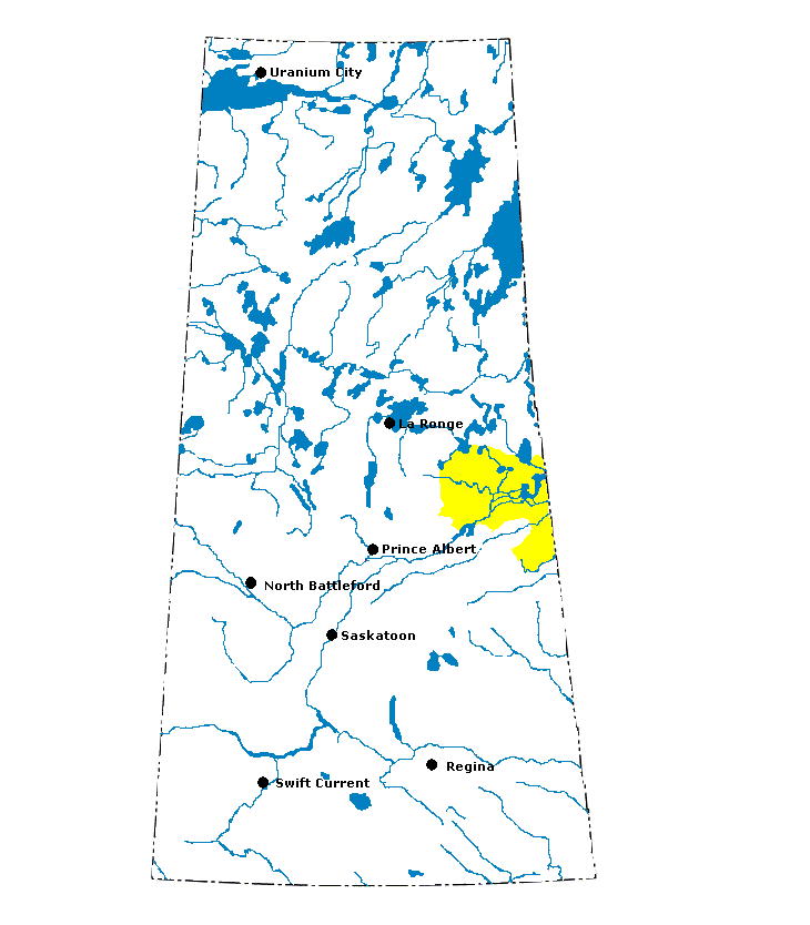
Mid-Boreal Lowland: This ecoregion occupies the northern section of the Manitoba Plain from the eastern shore of Lake Winnipeg to the Cumberland Lowlands in Saskatchewan. The climate is marked by short, warm summers and cold winters. The mean annual temperature is approximately -1°C. The mean summer temperature is 13.5°C and the mean winter temperature is -17°C. The mean annual precipitation ranges from 375 mm in the northwest to 625 mm in the southeast. The ecoregion is classified as having a subhumid mid-boreal ecoclimate. It is part of the boreal mixed coniferous and deciduous forest, extending from Lac Seul in northwestern Ontario to the foothills of the Rocky Mountains. It is a relatively flat, low-lying region with extensive wetlands covering approximately half the area. The cold and poorly drained fens and bogs are covered with tamarack and black spruce. The mixed deciduous and coniferous forest is characterized by medium to tall, closed stands of trembling aspen and balsam poplar with white and black spruce, and balsam fir occurring in late successional stages. Permafrost occurs in isolated patches in peatlands and is more prevalent in the regions northeastern section. Underlain by flat-lying, Palaeozoic limestone bedrock, the ecoregion is covered almost entirely by level to ridged glacial till, lacustrine silts and clays, and extensive peat deposits. Eutric Brunisols developed on extremely calcareous, loamy glacial till and Mesisols on forest peat are codominant, and are associated with local areas of limestone bedrock outcroppings and Gray Luvisols on loamy to clayey-textured lacustrine deposits. Wildlife includes moose, black bear, wolf, lynx, showshoe hare, waterfowl (including duck, goose, pelican, and sandhill crane), ruffed grouse, and other birds. Pulpwood and local sawlog forestry, water-oriented recreation, and wildlife trapping and hunting are the dominant uses of land in this region, although seed grains, oilseeds and forage crops are produced where soils and drainage are suitable. The major communities include The Pas and Grand Rapids. The population of the ecoregion is approximately 18,300.
|
|
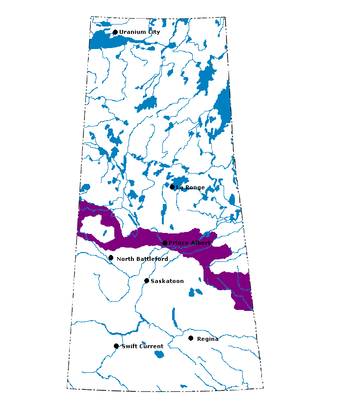
Boreal Transition: This ecoregion extends from southern Manitoba to central Alberta. The ecoregion is characterized by warm summers and cold winters. The mean annual temperature is approximately 1°C. The mean summer temperature is 14°C and the mean winter temperature is -13.5°C. The mean annual precipitation ranges from 450 mm in the west to 550 mm in the east. The ecoregion is classified as having a subhumid low boreal ecoclimate. As part of the dominantly deciduous boreal forest, it is characterized by a mix of forest and farmland. It marks the southern limit of closed boreal forest and northern advance of arable agriculture. A closed cover of tall, trembling aspen with secondary quantities of balsam poplar, a thick understory of mixed herbs, and tall shrubs is the predominant vegetation. White spruce and balsam fir are the climax species, but are not well represented because of fires. Poorly drained sites are usually covered with sedges, willow, some black spruce, and tamarack. Underlain by Cretaceous shale, this hummocky to kettled plain is covered by calcareous, glacial till and significant inclusions of relatively level lacustrine deposits. Associated with the rougher morainal deposits are a large number of small lakes, ponds, and sloughs occupying shallow depressions. The region drains northeastward via the Saskatchewan River system. Well- to imperfectly drained Gray Luvisols and Dark Gray Chernozemic soils are predominant. Local areas of Black Chernozemic, peaty Gleysolic, and Mesisolic soils also occur. The region also provides habitat for white-tailed deer, black bear, moose, beaver, coyote, snowshoe hare, and cottontail. It also provides critical habitat for large numbers of neotropical migrant bird species, as well as ruffed grouse and waterfowl. Over 70% of the ecoregion is farmland; spring wheat and other cereals, oilseeds, and hay are the dominant crops. Other land uses include forestry, hunting, fishing, and recreation. The major communities include Athabasca, Lac la Biche, Meadow Lake, Prince Albert, Melfort, Hudson Bay, and Kamsack. The population of the ecoregion is approximately 298,100.
|
|
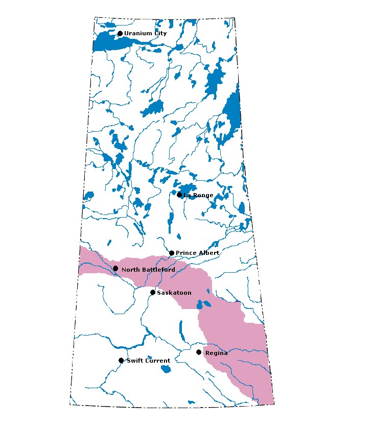
Aspen Parkland: This ecoregion extends in a broad arc from southwestern Manitoba, northwestward through Saskatchewan to its northern apex in central Alberta. The parkland is considered transitional between the boreal forest to the north and the grasslands to the south. The climate is marked by short, warm summers and long, cold winters with continuous snow cover. The mean annual temperature is approximately 1.5°C. The mean summer temperature is 15°C and the mean winter temperature is -12.5°C. The mean annual precipitation ranges from 400–500 mm. The ecoregion is classified as having a transitional grassland ecoclimate. Most of the ecoregion is now farmland, but in its native state the landscape was characterized by trembling aspen, oak groves, mixed tall shrubs, and intermittent fescue grasslands. Open stands of trembling aspen and shrubs occur on most sites, and bur oak and grassland communities occupy increasingly drier sites on loamy Black Chernozemic soils. Poorly drained Gleysolic soils support willow and sedge species. This broad plains region, underlain by Cretaceous shale, is covered by undulating to kettled, calcareous, glacial till with significant areas of level lacustrine and hummocky to ridged fluvioglacial deposits. Associated with the rougher hummocky glacial till, landscapes are numerous tree-ringed, small lakes, ponds, and sloughs that provide a major habitat for waterfowl. The ecoregion also provides a major breeding habitat for waterfowl and includes habitat for white-tailed deer, coyote, snowshoe hare, cottontail, red fox, northern pocket gopher, Franklins ground squirrel, and bird species like sharp-tailed grouse and black-billed magpie. Because of its favourable climate and fertile, warm black soils, this ecoregion represents some of the most productive agricultural land in the Prairies. It produces a wide diversity of crops, including spring wheat and other cereals, oilseeds, forages, and several specialty crops. Dryland continuous cropping methods for spring wheat and other cereal grains are prevalent. Major communities include Red Deer, Edmonton, Lloydminster, North Battleford, Humboldt, Yorkton, and Brandon. The population of the ecoregion is approximately 1,689,000.
|
|
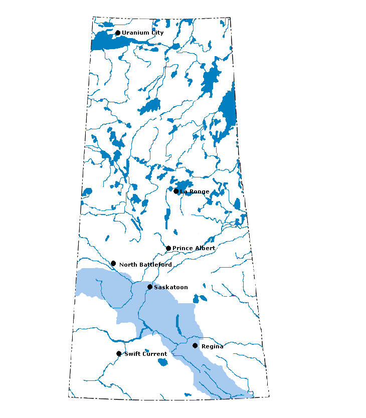
Moist Mixed Grassland: This ecoregion comprises the northern extension of open grasslands in the Interior Plains of Canada and is closely correlated with semiarid moisture conditions and Dark Brown Chernozemic soils. The mean annual temperature is approximately 2.5°C. In some areas of southwestern Alberta the mean annual temperature can reach 5°C. The mean summer temperature is 15.5°C and the mean winter temperature is -11°C. The mean annual precipitation ranges from 350–400 mm. Native vegetation is relegated to nonarable pasturelands, dominated by spear grass and wheat grass, and a variety of deciduous shrubs including buckbrush, chokecherry, wolf willow, and saskatoon. Patches of scrubby aspen, willow, cottonwood, and box-elder occur to a limited extent on shaded slopes of valleys, on river terraces, and ringing nonsaline depressional sites covered with meadow grasses and sedges. Local saline soil areas support alkali grass, wild barley, red sampire, and sea blite. The region is composed of upper Cretaceous sediments and covered almost entirely by hummocky to kettled glacial till and level to very gently undulating, sandy to clayey lacustrine deposits. Although Dark Brown Chernozemic soils are dominant, significant areas of Solonetzic soils occur, particularly in eastern Alberta. Intermittent sloughs and ponds provide habitat for waterfowl. White-tailed deer, pronghorn antelope, coyote, rabbit, and ground squirrel are common in the region. Spring wheat and other cereal grains are produced by employing a wheat or other grain-fallow rotation. Oilseed crops are also becoming increasingly important. Minor irrigation of these crops occurs near Lake Diefenbaker in Saskatchewan and in southern Alberta. Waterfowl hunting is common, and recreation is important around several large reservoirs. Major communities include Fort Macleod, Lethbridge, Drumheller, Rosetown, Unity, Biggar, Saskatoon, Moose Jaw, Regina, Estevan, and Weyburn. The total population of the ecoregion is approximately 656,000.
|
|
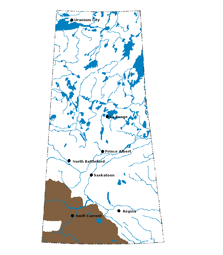
Mixed Grassland: This semiarid grassland ecoregion in southwestern Saskatchewan and southeastern Alberta forms part of the shortgrass prairie in the Great Plains of North America. The mean annual temperature is approximately 3.5°C. In southern Alberta, west of the Cypress Upland ecoregion, mean annual temperatures can exceed 5°C. The mean summer temperature is 16°C and the mean winter temperature is -10°C. The mean annual precipitation ranges from 250–350 mm. Moisture deficits in late summer are caused by low precipitation and high evapotranspiration. The natural vegetative cover is dominated by spear grass, blue grama grass, and wheat grass. June grass and dryland sedge are significant associates. Blue grama and spear grass predominate on drier sites, along with dwarf sedges. A variety of shrubs and herbs also occurs, but sagebrush is most abundant, and on the driest sites yellow cactus and prickly pear can be found. Scrubby aspen, willow, cottonwood, and box-elder occur to a limited extent on shaded slopes of valleys and river terraces. Local saline areas support alkali grass, wild barley, greasewood, red sampire, and sea blite. The region is composed of upper Cretaceous sediments and is covered almost entirely by dissected to kettled, loamy glacial till, undulating to dissected, loamy lacustrine sediments, and hummocky sandy eolian deposits. The region skirts the Cypress Hills, with the area to the south being drained by the Missouri River system, and the area to the north by the South Saskatchewan River. The soils are mainly Brown Chernozemic with significant areas of Solonetzic soils. Pronghorn antelope, deer, sage grouse, short-horned lizard, western rattlesnake, coyote, rabbit, and ground squirrel are common species in the region. The production of spring wheat and other cereal grains occurs by employing a grain-fallow rotation. Flaxseed and durum wheat are also grown. About half of the region is cultivated with the remainder being used for pasture or rangeland. As part of the North American waterfowl migratory flyway and with its diverse wildlife habitat, the region provides opportunities for hunting and recreation. The major communities include Medicine Hat, Leader, Swift Current, Assiniboia, Maple Creek, Shaunavon, and Kindersley. The population of the ecoregion is approximately 187,200.
|
|
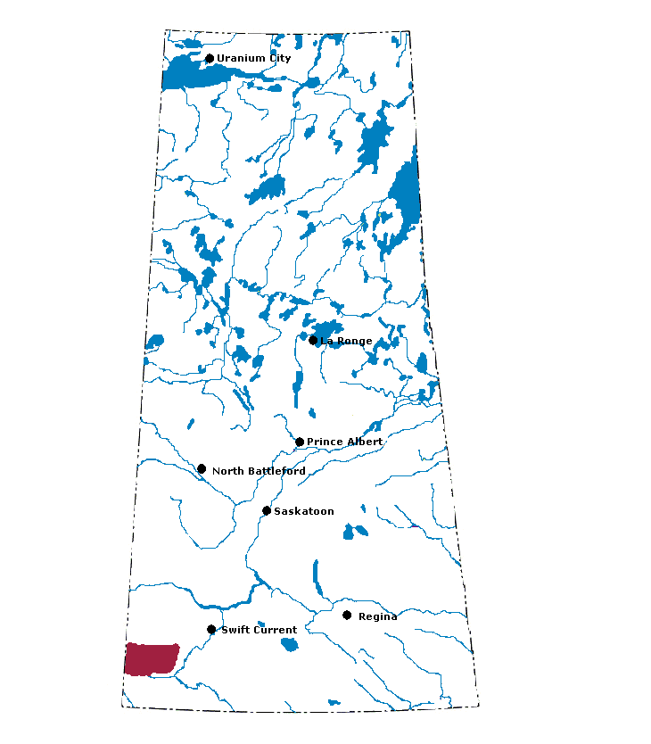
Cypress Upland: This rolling upland in southeastern Alberta and southwestern Saskatchewan is an outlier of the montane vegetative zone that occurs on the lower slopes of the Rocky Mountains. The climate is cooler and moister than the surrounding Mixed Grassland ecoregion. The mean annual temperature is approximately 3°C. The mean summer temperature is 15°C and the mean winter temperature is -9°C. The mean annual precipitation ranges from 325–450 mm. The Cypress Hills, rising abruptly 400–500 m above the surrounding plains, are composed of a mix of dissected Tertiary and Cretaceous sediments covered with glacial till, or with loessial deposits on unglaciated upper plateau sections. The Cypress Hills slope eastwards from a maximum elevation of 1,465 m asl at the west side. Natural vegetation ranges from fescue and wheatgrass grasslands below 1,000 m to a mixed montane-type open forest of lodgepole pine, deciduous trees, and shrubs at upper elevations. Numerous species, including larkspur, death camas, and wild lupine, are not found elsewhere on the prairies. Chernozemic Black and Dark Brown soils are dominant. Luvisolic soils under pine forests and loamy Regosolic soils on eroded valley slopes are also present. The ecoregion slopes eastward and is drained by deeply incised Frenchman River, and Battle and Swift Current creeks. Mule and white-tailed deer, pronghorn antelope, sage grouse, short-horned lizard, western rattlesnake, coyote, rabbit, and ground squirrel are common in the region. Audubons warbler is a unique bird that is not found elsewhere on the prairies. Physical conditions allow free-range livestock grazing and limited production of cereals on smoother lower slopes. Wildlife hunting and recreation are also important uses on rougher upper slopes. The population of the ecoregion is approximately 3,900.
|
|
